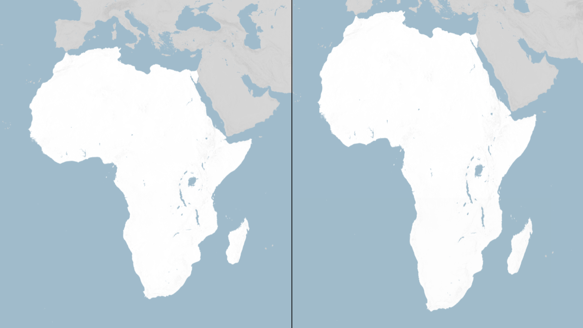
Why Togo’s extraordinary diplomatic victory at the United Nations is about far more than cartography
For more than four centuries, children have gazed at a world where Greenland looms almost as large as Africa. It isn’t. Africa is fourteen times bigger. Yet the Mercator projection, designed in 1569 to aid sailors, became the world’s most influential visual narrative. By inflating territories near the poles and shrinking those near the equator, it rendered Africa perpetually small. On 4 September 2026, the United Nations General Assembly overwhelmingly endorsed the “Correct the Map” resolution, promoting equal-area projections such as Equal Earth. The vote: 164 in favour, one against, six abstentions. The country behind it was not one of Africa’s giants. It was Togo. That deserves recognition.
First, let us correct the correction.
Africa is not the world’s largest continent. Asia is. Africa spans roughly 30.3 million square kilometres — considerable, but not the biggest. What the new projection does is show Africa’s true relative scale, not make it the largest. And the United States did not abstain; it voted against. The six abstentions were Estonia, Georgia, Lithuania, Moldova, Serbia and Ukraine. These distinctions matter because if Africa is arguing for accurate representation, the argument itself must be accurate.
So what exactly did the UN do?
The UN has not banned the Mercator projection or physically changed every map overnight. The resolution is non-binding. It encourages governments, schools, media and technology companies to use equal-area projections — particularly Equal Earth — when relative size matters. Mercator remains useful for navigation. This is not simply “the old map is illegal, here is the new one.” It is far more significant: the UN has acknowledged that how humanity represents the world influences how humanity thinks about it. And that is where this story becomes much bigger than geography.
Is this psychological? Absolutely — but that does not make it insignificant.
Maps are not mere paper. They are educational instruments, visual narratives. A child who repeatedly sees Africa occupying a small portion of the world can unconsciously internalise Africa as geographically marginal. But Africa is anything but marginal. It is enormous. It stretches from the Mediterranean to the southern tip, from the Atlantic to the Indian Ocean, containing fifty-four countries, over a billion people, and vast agricultural, mineral, energy and human resources. The Mercator distortion does not deliberately weaken Africa politically or economically. But visual perception matters. The UN resolution explicitly links cartographic representation to education, public understanding and perceptions of Africa. Yes, there is a psychological dimension. Perhaps that is precisely why the debate matters.
A map cannot industrialise Africa
Here Africa must be careful. Changing the map does not build a railway, create a textile factory, process African minerals, create jobs, stop capital flight, transform raw materials into manufactured products, or create political stability. Africa cannot allow cartographic recognition to become a substitute for economic transformation. The real victory will come when the world sees Africa not merely as a large geographical space but as a productive economic force. That means African cotton is used to make textiles and clothing. African minerals are processed into manufacturing. African agricultural products are processed into agro-products and exported. African energy into industrialisation. African young people into skills, enterprises and industries. That is when the psychological map and the economic map begin to converge.
And this is why Togo deserves enormous credit.
It would have been easy for Togo to conclude the world’s map was someone else’s problem. Instead, it took an issue many governments dismiss as symbolic and turned it into an international diplomatic campaign. Advanced by Togo on behalf of the African Group and supported by the African Union, this was strategic diplomacy. Togo effectively asked, ‘If representation matters, why should Africa continue to be represented inaccurately?’ Foreign Minister Robert Dussey framed the issue in terms of how maps influence education, imagination and collective perceptions. There is a deeper lesson: Africa often complains — correctly — that the global system does not adequately reflect its interests. But this initiative demonstrates something important — Africa can shape the international agenda. Not by waiting for Washington, Brussels or Beijing, but by organising around an idea, building coalitions and taking that idea to the international system. That is worth celebrating.
What does this mean for America?
The United States was not merely absent; it was the only country to vote against. Washington’s representative argued the initiative was part of a broader ideological project involving “reparations” and “cognitive justice”, and that the UN should concentrate on peace and prosperity. The U.S. explicitly voted “no”. From Washington’s perspective, the argument is understandable — why spend diplomatic energy on map projections when wars, poverty, displacement, debt, climate change and international security remain unresolved? That is legitimate. But there is another view: America’s decision may inadvertently have given the Togo-led initiative even greater symbolic power. When 164 countries say yes and the world’s most powerful country says no, the vote itself becomes part of the story. The United States may have intended to reject ideological symbolism; instead, it became the lone dissenting voice on a resolution the overwhelming majority considered reasonable. That creates an interesting diplomatic optics problem for Washington.
But should we interpret America’s vote as opposition to Africa?
No. That would be too simplistic. The U.S. position was opposition to the resolution and its ideological framing, not a declaration that Africa is geographically smaller than it is. And here is an irony: Equal Earth was developed by cartographers including Tom Patterson, a former senior cartographer at the U.S. National Park Service, together with Bernhard Jenny and Bojan Šavrič. This is not an African invention designed to attack America. It is a legitimate cartographic response to a genuine technical problem — you cannot accurately flatten a spherical Earth onto a rectangular surface without distortion. Every projection makes compromises. The real question is which distortion is appropriate for which purpose.
The bigger African question: will we stop at the map?
This is where African leaders should take the debate. The new map should become a metaphor for a much bigger transformation. For centuries, Africa has often been seen as small while being geographically enormous. Now Africa must ensure its economic weight catches up with its physical scale. The continent cannot simply demand the world change the way it looks at Africa; Africa must also change the reality the world sees. If Africa is the world’s second-largest continent by land area, why should so much of its raw material leave unprocessed? If Africa has enormous agricultural land, why does it import so much processed food and clothing? If Africa has some of the world’s largest mineral reserves, why are so many higher-value processing stages conducted elsewhere? If Africa has one of the world’s youngest populations, why is that demographic dividend so often discussed as a problem rather than an industrial opportunity? That is the real map that needs correcting.
From psychological correction to economic correction
The significance of the UN vote lies in three layers. First, the geographical correction: Africa should be represented according to its actual size. Second, the psychological correction: African children should grow up seeing their continent accurately — not as a peripheral appendage of Europe but as a vast central part of the planet. Third, the economic correction: Africa must transform its enormous physical and human resources into industrial power. The first two can influence the third because perception affects ambition, and ambition affects policy.
Togo has shown what small countries can do.
There is a final lesson here that goes beyond Africa. Togo is not Nigeria, South Africa, Egypt, Ethiopia or the Democratic Republic of Congo. It is a relatively small West African country. Yet it placed an issue on the UN agenda and secured an extraordinary 164-country majority. That is a lesson in diplomacy: a country’s influence is not determined only by the size of its GDP, military or population. Sometimes influence comes from owning an idea and persuading others that the idea matters. Togo did that. For that reason, Togo deserves to be hailed.
THE REAL STORY IS NOT THAT AFRICA GOT BIGGER.
Africa did not suddenly become larger on 4 September 2026. Africa was always this large. The map was the problem — not the continent. And perhaps that is the most powerful message coming out of New York. The UN has not changed Africa’s geography; it has challenged the way geography is communicated. Now Africa has an opportunity to take the next step. Correct the map. Correct the narrative. Then correct the economic structure. Because the ultimate victory will not be when Africa looks bigger on a map. It will be when Africa’s industrial capacity, economic power, political influence and global voice reflect the enormous continent that has been there all along. That is why this apparently strange story about a map may turn out to be a much bigger story about Africa’s psychological liberation — and its unfinished economic liberation.
Togo started the conversation. The rest of Africa now has to build the reality.
Comments
Be the first to comment.